The entire Northern part of the Indian Subcontinent forms a giant biosphere. This eco-system, one of the most diverse in the whole world, owes the abundance of life to several great rivers flowing thorough this region. And all of these rivers starts from the high glaciers of the Himalayas, the largest and tallest of all mountains. It comes as no surprise that billions of people of these regions humble themselves at the feet of these mountains and rivers. We literally owe our lives to the Great mountains and mighty rivers that flow from them. For centuries these pristine glaciers have attracted adventurers and pilgrims alike.
I along with my friends followed the Pindar river to the fabled Pindari glacier (3660 mtrs) and the journey has been a fabulous experience for us.
Warning Signs; An Appeal:
The glaciers melt throughout the year and form the rivers and every winter it rebuilds itself from rain and snow. But due to global warming, the average temperature is rising every year and the glaciers are melting away at a much faster rate than it can build itself. This glacial recession is happening right now, and it is happening more rapidly than the glaciologists have anticipated. When I visited Pindari glacier and compared the current state with the photographs my mother took, about 30 years ago, I was shocked to see how much of the glacier had eroded away.
I urge the readers to do their part to make sure these glaciers survive, otherwise the entire ecosystem will be devastated within this century.
1. Do not litter the trek routes, carry back every bit of plastic you bring with you.
2. Do not cut tree branches unnecessarily . Do not pick flowers or plants.
" Take nothing but photographs, leave nothing but footprints"
"These mountains are associated with the best memories of our race: Here, therefore, must be one of centres, not merely of activity, but more of calmness of meditation, and of peace and I hope some one to realise it"
As our car teared through the busy streets of Almora, we stared at the bright majestic peaks of central Himalayas towering over the clouds. Weary and hungry, we reached the town of Bageswar after 1 pm. It was really hot as the town is situated at a valley and small buildings covered most of the surrounding hills. The idea of spending a night here did not seem justifiable and just like that we scrapped our months of planning and decided to push ahead. Unfortunately all direct jeeps to Kharkiya had left early in the morning. We booked a car to Bharari ( about 30 km ahead) for 800/- and the driver ensured us that we could get a car to Kharkiya from there. The road to Bharari stretches alongside river Sarayu. Just 1 km from the village of Kapkote the car turned left to cross a bridge across Sarayu and we were at Bharari. There were several jeeps parked along the narrow road. Our driver asked each and every driver to take us to our destination. Most of them reluctantly declined, the rest asked for unreasonable amounts as high as 5000/-. Just when everything seemed hopeless, a middle aged guy agreed to our proposal for 2300/- .
He explained that in the monsoon season this particular road had been damaged badly and most drivers were either not capable of tackling the road or too scared. Within half an hour we understood what he meant. Only a car with powerful 4 wheel drive with an experienced driver with nerves of steel behind its wheel can take on this so called 'road'. There were loose boulders everywhere, the road was narrow to begin with, and with repair works going on, there was just enough room for one car to barely pass. At one point the driver had to drive over loose rocks on a very steep downhill slope, any mistake surely would have resulted in our death.Throughout our 2 and a half hour long journey it felt like we had been put inside a box and someone was shaking it vigorously. Just before 5 pm we reached the Kharkiya village. We thanked our driver from the bottom of our hearts for the ride.

We could only imagine how nerve racking his journey had been for him. He originally planned to return the same day but seeing the dark clouds overhead he decided to stay.

Rain held us up at Phurkia for an extra day. We decided to start as early as possible and reach Dwali. There were some tough decisions to be made. We talked among ourselves and decided that we will not take unnecessary risk of going to Kafni unless we get news from Dwali that the route was open and the rest house in Khatiya was in service. Still hoping for the best we set out towards Dwali. There was not a single spec of cloud in the sky and we wished we had similar weather the previous day. The path is down hill and though the rain had made the trail a bit slippery we picked up the pace. By our calculations we should reach Dwali within 2 hours and after one and a half hour we asked Amit Ji to go on ahead and order alu parathas for us at Dwali.
Cooking takes a awful lot of time in the hills and it seemed like a good idea. After 20 minutes or so one of my companions pointed out to something in the mud which looked like a paw print. Despite the large size we ignored it as shepherd dog and kept on moving. After reaching Dwali we found our guide sitting outside a small hotel, looking worried and pale. As we came to hearing distance he shouted 'bhaloo tha jungle me, bhojan kar leta wo mera aj', meaning, there was a bear in the jungle and it could have made a meal out of our scared guide. Whether he was telling the truth or trying to scare us, we shall never know, but we decided not to get separated from the group.
Upon enquiring the locals we found out that we could not go to Kafni Glacier without proper support. Some of them asked us to wait for a few days or come next year. We knew we had to move on, our itinerary changed again.
Itinerary 3
After our breakfast we started our descent. Remembering our uphill journey our guide had advised to stay at Dwali but I decided to go to Khati and assured him we can make it there before 3 pm. Amit Ji led us through the river bank and soon we were at the base of that waterfall. The though of the steep climb through the muddy path sent a chill down my spine. We were surprised to see our guide ignoring the waterfall and walking straight along the riverbed. Seeing our confusion he said ' Bharosa rakkho', 'trust me '. Soon we realised that we were taking the old route through the riverbed and from the footprints it was apparent that many locals were still using it. We found our way through the maze of boulders and small streams, keeping an eye out for footprints. We could see huge landslide zones to our right and hurried past them. We were tired, but we could feel that we were making better progress than we would have made by following the new route. After 2 hours of walking down the river-bank we saw our guide jump over a small stream. He motioned us to wait and disappeared into the bushes. A full 5 minutes later we could see him motioning us to follow him. Unfortunately we could not follow the river any longer and we climbed through bushes and slippery rocks covered with moss. After a few minutes we found ourselves panting and puffing on a stone paved path.
We were back on the new trail. It took another two hours till we reached the bridge near Khati village. Our guide suggested that we finish our packed lunch on the river bank, we obliged gratefully. We spotted a small bird splashing on the roaring Pindar as if playing a game of tag with the mighty river. After filling ourselves up with the alu parathas we brought from Dwali and quenching our thirst with the refreshing river water we prepared ourselves for the final phase of the day's journey.
It took us over 1 hour to reach this point from Khati and it will take atleast twice as long to get back up again. It took a lot of effort to climb to the top of the landslide point. Our guide was bent on taking us to a home stay of his friend at Khati but we wanted to stay at the secluded KMVN guest house away from the village. Just as we were passing in front of the KMVN cottages, it started to rain. We ran towards the cottages for shelter and mother nature decided our accommodation for us. The rooms were locked and nowhere was there, we asked Amit Ji to go to the village and bring the caretaker, while we wait on the porch. It was 3 pm, just as I had predicted. We put on our woolens as the temperature plummeted and our sweaty clothes chilled us down to the bone. It was raining very heavily indicating that the weather would remain clear afterwards. After 40 minutes or so we could see three figures carrying umbrellas moving slowly towards us, our guide had successfully brought the caretakers. After customary greetings they immediately set to work, preparing a room and food for us. The food from the picnic down at the river bank was surely digested by now. The great thing about Mountain hiking is no matter how much you eat, after a few hours you are hungry again, provided you are not suffering from altitude sickness.
After our second lunch at about 5 pm, the caretaker came to us with an unusual request. He also runs a home-stay down at the village and because he had guests there he would not be able to stay after 7pm, and we would have to have our dinner before that. We refused, instead offered that we would cook our own dinner, a win-win situation.
The rain ceased just before the sunset and we decided to climb a bit to the cottage which was situated a bit higher than the one we were staying in. The entry was blocked by thorny bushes to block entry of cows and other animals. We went past the blockade carefully. Apparently these cottages were still undergoing construction and hence closed for visitors, but unfortunately they had the best view in all of Khati village. It was perhaps the only place from where you could see some of the peaks. We took quite a few pictures till the sunset and hurried to our own cottage, not willing to risk finding our way in the dark.
The evening was particularly fun as we cozied up in the warmth of the kitchen fire. The next two hours flew past as we practically ransacked the kitchen to find various spices and cook egg curry and khichdi. Each one of us including Amit ji was delighted after having our dinner. He hurried off to sleep after locking up the kitchen.
We stuck around a bit more, taking a few snaps of the galaxy overhead before surrendering our tired body to the comfort of warm soft blankets.
The next morning we checked ourselves out after making noodles and coffee for breakfast. Our guide locked everything up and took off to pay the caretaker. The caretaker had already prepared a bill the day before and we paid the amount to our guide friend. We descended from the lush forests to the colourful village. As we retraced our path to Kharkiya, the red ramdana fields again captured our admiration.

We were basically in the mood for a leisurely stroll and at noon we were at Kharkiya, sipping tea. Dhakuri is about 3.5 km uphill from Kharkiya and like most days clouds were starting to gather. We decided not to stop at the guide's family guest house for lunch despite his protests. We knew it will take at-least an hour to prepare food and it might start raining. We bought some biscuits and started our ascend towards Dhakuri while our guide stayed back for some home cooked meal.
The first phase of the walk takes you through extension of the Kharkiya village and its adjacent crop fields. We met some bright eyed children along the way who greeted us with beautiful smiles. We offered them candies as bribes to see them smile again.

The village ends after 1.5 km or so, then the trail takes you through lush green meadows and forests of deodar and pine. At this point our guide caught up with us and I advised him to take one of my friends and arrange for lunch and accommodation at Dhakuri. They sped off ahead of us. This part of the forest was quiet and we spotted several tree-pies, magpies and other species of birds unknown to us. The constant uphill climb took a bit of toll on us and just when we were thinking of taking a break and sit somewhere, we spotted a bright pink building peeping through the forest. "It must be Dhakuri" my friend exclaimed excitedly and the very next moment we were walking at top speed. By 2.40 pm we reached the Dhakuri top.
Here one have the luxury to choose from various accomodation options, FRH, KMVN guest-houses and tents. The FRH guest house has the best view because it is situated on higher grounds but some foreigners were already occupying it. So we settled in a dorm type room in KMVN rest house. By 3.15 pm we were sitting by the kitchen fire eating rice, dal and cabbage sabji.
The clouds made it impossible to enjoy the view that afternoon. There were some noisy neighbours, with recorded music, guitars, games etc. I do not get people who need additional entertainment to enjoy the mountains. But either way we were grateful when we heard that the generator would run for an hour in the evening courtesy of our neighbours because both my camera batteries were almost dead.

After sunset the clouds cleared off and after an early dinner we went out for customary star-gazing in the dark.
The Dhakuri top is a perfect lawn, with soft natural grass and amazing views of the mountains and we were mesmerised by the ineffable beauty of this place. The photographs taken by us do not do justice to the actual vistas.

After filling ourselves with roti, rai shak (a type of mustard leaves, a bit bitter in taste) and omelette we started climbing up the hill towards the temple of Chilta/ Chiltha Mai. After half an hour we came across a small pass, which leads down towards Loharkhet. This is the saddle between two hills overlooking Dhakuri top. Both hill tops has a temple of Chiltha Mata each, the left one is 2 km away deep inside the jungle and the right one is more accessible and only a kilometer away.
We voted to go to the one on the right as the view was supposed to be the same. After climbing for a few minutes the forest ended and we saw a grassy carpet going all the way to the top. We stopped to catch our breath and breath in the surreal beauty of this meadow. This is one of the best places to enjoy unhindered view of the Kumaon Himalayas. We met two youths from Delhi who were descending and they rushed off after exchnaging greetings towards the other hill-top. After repeated persuasion by our guide we started climbing further and reached the temple.
We had incense sticks and food and offered them to the Goddess and asked for her blessings. It was 10.30 and we decided to get down before lunch time. The descent was much faster than anticipated and within the next hour we were lying peacefully on the sunny lawn of KMVN guest house.
We spent the rest of the day reminiscing memories of our delightful journey and lazing about. The next day we were about to get down to the so called 'civilization'. A tinge of sadness crept into the colourful painting of happy memories as we planned for our descent.
Loharkhet is a 11 km downhill trek from Dhakuri though the first kilometer and a half is uphill. As I mentioned before, the route passes through saddle below the Chiltha Mata temples. We started walking early in the misty morning. The long, seemingly never-ending downhill walk fatigued my lower limbs to the extent that I was limping. about 5 km from Loharkhet we met two trekkers climbing up who notified us that our driver (who was pre-arranged by our guide ) was waiting at Loharkhet.

There is a small tea-stall at about 4 km above Loharkhet. We met a few cyclists on their way up and learned that they would ride their bikes to the zero point. We could see our car waiting down below and was relieved. Previously the motor-able road ended at Song/ Saung village which is 4km downhill from Loharkhet now the road had been extended till Loharkhet. Many trekkers prefer to start the trek to Pindari Glacier from Song/ Loharkhet. Loharkhet has a Forest Rest house where one could spend the night.
As our car zoomed past the Saung village a strange sadness gripped our hearts, our faint sighs made a solemn promise ' we shall return again'.
I along with my friends followed the Pindar river to the fabled Pindari glacier (3660 mtrs) and the journey has been a fabulous experience for us.
Warning Signs; An Appeal:
The glaciers melt throughout the year and form the rivers and every winter it rebuilds itself from rain and snow. But due to global warming, the average temperature is rising every year and the glaciers are melting away at a much faster rate than it can build itself. This glacial recession is happening right now, and it is happening more rapidly than the glaciologists have anticipated. When I visited Pindari glacier and compared the current state with the photographs my mother took, about 30 years ago, I was shocked to see how much of the glacier had eroded away.
I urge the readers to do their part to make sure these glaciers survive, otherwise the entire ecosystem will be devastated within this century.
1. Do not litter the trek routes, carry back every bit of plastic you bring with you.
2. Do not cut tree branches unnecessarily . Do not pick flowers or plants.
" Take nothing but photographs, leave nothing but footprints"

Reunions with old friends always make the happiest memories and if one of those reunions happens at the foothills of the highest mountain range of the world, well, you can't beat that. This was the feeling I got after meeting two of my closest friends outside the Kathgodam Railway station on a fine September morning. Daylight barely kissed the world as we started our journey. We had arranged a car to take us to Bageswar for 2500/-. The journey was over 160km and was supposed to take about 6 hours. After about an hour we reached Bhimtal (read Chilling out in Style at Jilling).
It is a beautiful lake surrounded by lush Green forest and a few buildings, hotels mostly. At about 8, we stopped for breakfast at a roadside restaurant. The owner prepared steaming hot alu parathas and rajma dal for us and we gobbled them up as soon as they cooled down to a manageable temperature. Our journey resumed and time flew as we tried to catch up with each other. We reminisced old memories from our college days, shared recent events of our lives, laughed at old jokes, while listening to local Kumaoni and Bollywood numbers being played on the car's stereo, breathing in the fresh cool mountain air and feasting our eyes on the incredible vistas.
By 10 O' clock we reached Almora. This hill town is well known for its beauty. Rabindranath Tagore spent a few of his summers as well as his last vacation here and one can see why it inspires creativity. Even Swami Vivekanada said in his speech to the people of Almora-
 |
Bhimtal |
It is a beautiful lake surrounded by lush Green forest and a few buildings, hotels mostly. At about 8, we stopped for breakfast at a roadside restaurant. The owner prepared steaming hot alu parathas and rajma dal for us and we gobbled them up as soon as they cooled down to a manageable temperature. Our journey resumed and time flew as we tried to catch up with each other. We reminisced old memories from our college days, shared recent events of our lives, laughed at old jokes, while listening to local Kumaoni and Bollywood numbers being played on the car's stereo, breathing in the fresh cool mountain air and feasting our eyes on the incredible vistas.
By 10 O' clock we reached Almora. This hill town is well known for its beauty. Rabindranath Tagore spent a few of his summers as well as his last vacation here and one can see why it inspires creativity. Even Swami Vivekanada said in his speech to the people of Almora-
"These mountains are associated with the best memories of our race: Here, therefore, must be one of centres, not merely of activity, but more of calmness of meditation, and of peace and I hope some one to realise it"
As our car teared through the busy streets of Almora, we stared at the bright majestic peaks of central Himalayas towering over the clouds. Weary and hungry, we reached the town of Bageswar after 1 pm. It was really hot as the town is situated at a valley and small buildings covered most of the surrounding hills. The idea of spending a night here did not seem justifiable and just like that we scrapped our months of planning and decided to push ahead. Unfortunately all direct jeeps to Kharkiya had left early in the morning. We booked a car to Bharari ( about 30 km ahead) for 800/- and the driver ensured us that we could get a car to Kharkiya from there. The road to Bharari stretches alongside river Sarayu. Just 1 km from the village of Kapkote the car turned left to cross a bridge across Sarayu and we were at Bharari. There were several jeeps parked along the narrow road. Our driver asked each and every driver to take us to our destination. Most of them reluctantly declined, the rest asked for unreasonable amounts as high as 5000/-. Just when everything seemed hopeless, a middle aged guy agreed to our proposal for 2300/- .
 |
Kharkiya |
He explained that in the monsoon season this particular road had been damaged badly and most drivers were either not capable of tackling the road or too scared. Within half an hour we understood what he meant. Only a car with powerful 4 wheel drive with an experienced driver with nerves of steel behind its wheel can take on this so called 'road'. There were loose boulders everywhere, the road was narrow to begin with, and with repair works going on, there was just enough room for one car to barely pass. At one point the driver had to drive over loose rocks on a very steep downhill slope, any mistake surely would have resulted in our death.Throughout our 2 and a half hour long journey it felt like we had been put inside a box and someone was shaking it vigorously. Just before 5 pm we reached the Kharkiya village. We thanked our driver from the bottom of our hearts for the ride.

We could only imagine how nerve racking his journey had been for him. He originally planned to return the same day but seeing the dark clouds overhead he decided to stay.
We availed a room at the first room-stay on the road. We knew that there was no electricity anywhere in the entire trek including Kharkiya. The landlord provided us with candles. After getting our bearings, we went out to the open verandah like space in front of the guest house. At a distance we could see the beautiful Nandakot peak slowly being covered by storm clouds. After a few more minutes it started pouring heavily, limiting visibility to only about 20-30 meters. We talked to the proprietor and asked him to arrange for a guide, who knows the routes to both Pindari and Kafni glaciers. After several minutes of discussion one of his sons, Amit Ji agreed to accompany us.
Previously our itinerary was as follows
Itinerary 1:
Day 1: Kathgodam to Bageswar
Day 2: Bageswar to Khati via Kharkiya (5 km trek)
Day 3: Khati to Dwali (11km trek)
Day 4: Dwali to Phurkia (5 km)
Day 5: Phurkia to Pindari ( 7km one way) and back to Dwali
Day 6: Dwali to Khatiya (6km)
Day 7: Khatiya to Kafni and back to Dwali (7 +7+6 = 20 km)
Day 8: Dwali to Khati
Day 9: Khati to Dhakuri (8.5km)
Day 10: Dhakuri to Loharkhet (11 km)
Day 6: Dwali to Khatiya (6km)
Day 7: Khatiya to Kafni and back to Dwali (7 +7+6 = 20 km)
Day 8: Dwali to Khati
Day 9: Khati to Dhakuri (8.5km)
Day 10: Dhakuri to Loharkhet (11 km)
But as we had gained a whole day by skipping the night stay at Bageswar and hence our plans changed. It never hurts to have a day or two extra in your trek itinerary.
Itinerary 2:
Day 1: Kathgodam to Kharkiya
Day 2: Kharkiya to Dwali via Khati (16 km)
Day 3: Dwali to Phurkia
Day 4: Round trip to Pindari and back to Dwali.
Day 5: Dwali to Khatiya
Day 6: Khatiya to Kafni and back to Dwali
Day 7: Dwali to Khati
Day 8: Khati to Dhakuri
Day 9: Dhakuri to Loharkhet
Day 5: Dwali to Khatiya
Day 6: Khatiya to Kafni and back to Dwali
Day 7: Dwali to Khati
Day 8: Khati to Dhakuri
Day 9: Dhakuri to Loharkhet
We knew that it would be tough to walk that much in the very first day, but nonetheless we decided to push ourselves.
 |
Nandakot: As Seen From Kharkiya |
The rain was showing no signs of letting up and we were worried, rains like these can mar an entire trek and literally pour cold water in your plans.
Our concerns grew as we heard that the post monsoon season had just begun and in their knowledge no team had yet been to Kafni Glacier and in all probability the trekker's Hut at Khatiya would remain closed. Let me elaborate a bit on Kafni Glacier (3860mtrs).
Pindari and Kafni glaciers are considered to be sisters from a trekker's point of view. In fact Kafni is hailed as more beautiful of the two and one can actually touch the glacial ice. Previously one could traverse the 11km trek to Kafni Glacier from Dwali and return the same day. After the devastating cloudbursts of June 2013 the consecutive flooding had washed off most trek routes of the region. From the next season, adventurers were forced to camp midway or stay at the trekker's Hut at Khatiya, which is about 6 km from Dwali. Without our own rations, tents and porters, it would be too risky to attempt Kafni Glacier if the trekkker's hut was closed.
Anyway, we had had a long day and after a hearty meal of roti, chawal, dal, achar, sabji and papad in the warmth of the kitchen, we turned in for the night in our room.
We started walking at 7.45 am. The weather was clear and we could see the almost blinding white massif of Nandakot (6861 mtrs). The 5 km first stretch of the trek is through small settlements. The villagers rely heavily on the wood from the forest for fuel and shelter, hence the signs of deforestation is quite apparent. We were sweating profusely, wishing there were more trees to provide us much needed protection from the sun. After about an hour we reached a home-stay, offering unhindered view of the mountains and sat under the stone tiled roof. We asked for some tea, scrambled eggs and noodles ( maggi) as we admired the beauty of this place. Just on the other side of the road one could see the red Ramdana / Chuye fields (a type of millet) highly contrasting with the green and yellow surroundings. To the right Khati village could be seen no further than 1.5 km away. After refueling ourselves we resumed our journey.
Khati is a beautiful village and the starting point of many treks such as the Sunderdunga glacier, Pangu top etc. The only problem is that the position of the village does not allow one to enjoy the views of the snow-capped mountains.
As we passed the village primary school we saw little children singing prayer songs in the lawn. Some unruly boys were hiding behind a rock waiting for the prayer to end, obviously their aim was to blend in without being detected. Thousands of miles from home, I got to relive a bit of my own childhood memories.
DAY 2: Kharkiya to Dwali (18-19 km)
We started walking at 7.45 am. The weather was clear and we could see the almost blinding white massif of Nandakot (6861 mtrs). The 5 km first stretch of the trek is through small settlements. The villagers rely heavily on the wood from the forest for fuel and shelter, hence the signs of deforestation is quite apparent. We were sweating profusely, wishing there were more trees to provide us much needed protection from the sun. After about an hour we reached a home-stay, offering unhindered view of the mountains and sat under the stone tiled roof. We asked for some tea, scrambled eggs and noodles ( maggi) as we admired the beauty of this place. Just on the other side of the road one could see the red Ramdana / Chuye fields (a type of millet) highly contrasting with the green and yellow surroundings. To the right Khati village could be seen no further than 1.5 km away. After refueling ourselves we resumed our journey.
 |
Ramdana Fields |
Khati is a beautiful village and the starting point of many treks such as the Sunderdunga glacier, Pangu top etc. The only problem is that the position of the village does not allow one to enjoy the views of the snow-capped mountains.
As we passed the village primary school we saw little children singing prayer songs in the lawn. Some unruly boys were hiding behind a rock waiting for the prayer to end, obviously their aim was to blend in without being detected. Thousands of miles from home, I got to relive a bit of my own childhood memories.
 |
Khati Village |
As we climbed up from Khati we came across the KMVN (Kumaon Mandal Vikash Nigam) Bungalows, secluded, surrounded by trees and practically hidden by the forest. After that we continued to climb upwards and saw the aftermath of a huge landslide. The entire face of the hill was missing.
The guide told us that it happened during the June 2013 catastrophe and it is the reason now people has to climb up to circumnavigate the landslide and then come down again to the riverbank. We reached the riverbank at 11 am. We crossed a makeshift wooden bridge after which the path turns right. Now we just had to follow the riverbank for like 9-10 kilometres and within 4-5 hours we would reach Dwali, or so we thought.
After 2013 the original path to Dwali was decimated, we could see the remnants of the old route at the left bank (left hand side when you look downstream) of the river Pindar. 2013 monsoon onward people had to walk alongside the river to get to Dwali. The local authorities finished a new path on the right bank just 2 days before we arrived and our guide, curious like most other locals was inclined to take it. We knew the riverbed route passes through several landslide zones and figured the new pathway would be much safer. The path is paved with stones like most of the trek routes in Uttarakhand and we enjoyed walking under the pine canopies. The weather was warm and the sky was clear and blue. After walking for almost 3 hours we met another party coming down. We asked about how far away was Dwali and they replied that we were about halfway there. We including our guide were confused. The new route adds a significant 3-4 km extra by taking you up and down needlessly. The labourers made the road by cutting the softer soil, paying no heed to the fact that it extended the total traversed distance. We had already traveled around 12 - 13 kilometres .
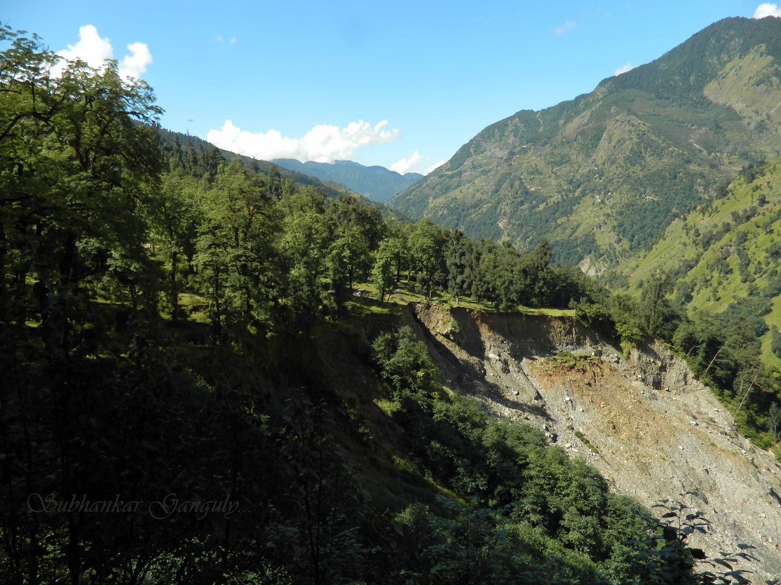 |
Khati Landslide |
The guide told us that it happened during the June 2013 catastrophe and it is the reason now people has to climb up to circumnavigate the landslide and then come down again to the riverbank. We reached the riverbank at 11 am. We crossed a makeshift wooden bridge after which the path turns right. Now we just had to follow the riverbank for like 9-10 kilometres and within 4-5 hours we would reach Dwali, or so we thought.
 |
Needs Updating |
 |
On the way to Khati |
Amit Ji, sensing our frustration said 'There is no other option but to keep moving forward', we knew he was right. Within the next hour, to make matters worse, the weather became really gloomy. Sensing a heavy shower we took out our umbrellas and rain coats. Luckily it did not start raining for another hour or so and even when it did it was just a drizzle. We were still about 300-400 feet above the river and wondering when we would start our descent to the river bank and make the river crossing to Dwali. At about 3.30 pm we were at our limit, it was not physical fatigue as much as mental. Even the guide did not know this route and this not knowing, affected our motivation. The constant downpour did not help to improve our already dampened mood either. Suddenly the path disappeared as we found ourselves in front of a roaring waterfall. We followed our guide through the muddy, steep narrow pathway to the bottom of the waterfall and jumped over boulders to cross it. We reached the river bank after negotiating another risky descent.
The riverbank was full of large boulders and there was no clear route so we kept moving upstream. It was 4.30 pm and Dwali was still not in sight. Someone had stacked small pebbles vertically as if to mark the way. We also found some arrow markings on the boulders, we knew we were close. Suddenly I saw one of my companions shouting excitedly and we saw a few cottages across the river. At Dwali the Kafni gad and Pindar rivers meet. We had to cross both rivers and then climb up to the cottages. We were hungry, tired, our clothes were soaked with sweat but the happiness and the relief we felt after reaching Dwali was indescribable. There are a few accommodation options to choose from, Rest houses managed by KMVN, PWD and the Forest Department as well as a few private home stays. We opted for KMVN and immediately ordered Khichdi and hot tea. We changed into fresh warm clothes and sat outside, happily sipping tea and gobbling up biscuits.

Dwali is surrounded by mountains and as the weather cleared we could see the Maiktoli peak from the front-yard. After dinner we stayed out for almost an hour admiring the skies. We spotted the glorious milky way and took a few long exposure shots.
We woke up and the great weather immediately energised us. The 9 hours of strenuous walk the previous day had prepared us for any challenge that lay ahead. The trek to Phurkia is undoubtedly the most enjoyable part of the trek because the destination is just 5km away. We set out at about 8.30 am after filling ourselves up with noodle soup and hot coffee. We walked at a gentle pace, enjoying the sunshine and blue skies.
All around us the birds were chirping in the bushes and trees. After about 2km the large alpine forest gave way to small bushes like Rhododendrons. We were spellbound by the sight of a rainbow inside a waterfall, we had seen nothing like it before.

We spotted a bugyal (meadow) just ahead and decided to rest there for a while. So far this grassland was obstructing our view and when we reached it we stood in awe. We savoured the view of pearly white Maiktoli in a backdrop of deep blue sky for almost an hour . After snacking on chocolate bars and biscuits we continued our ascent.
(Notice : Please do not throw away own chocolate wrappers and other non biodegradable wastes. Take a pledge to keep the Himalayas clean & green. )
Phurkia is not visible until you are at a stone throwing distance. There are trekker's Hut managed by KMVN, PWD and Forest department, even though the PWD one is more like a wreckage and I do not think it is fit for staying. KMVN has built a few igloo shaped structures for accommodation with walls made from reinforced synthetic thermal insulation.
They appeared to be quite spacious and comfortable, but because there were no cots we had to stay at the old Hut. We sat and chatted for hours basking in the sunlight and enjoying the unparalleled beauty of this place on a concrete slab behind the KMVN kitchen. The smell of cooking from the kitchen chimney accelerated our hunger as we waited impatiently for our lunch.Meanwhile out of nowhere black clouds covered up the sky and started pouring and we ran to the kitchen for shelter. We warmed ourselves by the wood fire and talked to the caretakers about our chances of making it to Kafni among other things. As far as they knew the route to Kafni had not opened till then and we could only go with tents and porters. After lunch we basically lazed about the rest of the day.
As per our plan we knew next day would be most strenuous and tiring day. So we had our lunch early and took rest.
Within a few minutes into the walk we started to hear a faint gurgling sound from some small waterfall nearby. The gurgle soon transformed into a roar as we found ourselves in front of a huge waterfall, riddled with boulders. Meanwhile our guide caught up with us from behind and helped us to cross tricky sections of the waterfall, navigating through strong current and extremely slippery rocks. We didn't noticed that daylight had started breaking the darkness near the horizon. Once we were through the section we were struck with awe by a breathtaking view of towering peaks moulded with molten gold. One of us expressed that this was the one of the very reasons to trek, to which we silently agreed.
 |
Top Left: The Waterfall; Top: Shepherds; Below: Dwali |
The riverbank was full of large boulders and there was no clear route so we kept moving upstream. It was 4.30 pm and Dwali was still not in sight. Someone had stacked small pebbles vertically as if to mark the way. We also found some arrow markings on the boulders, we knew we were close. Suddenly I saw one of my companions shouting excitedly and we saw a few cottages across the river. At Dwali the Kafni gad and Pindar rivers meet. We had to cross both rivers and then climb up to the cottages. We were hungry, tired, our clothes were soaked with sweat but the happiness and the relief we felt after reaching Dwali was indescribable. There are a few accommodation options to choose from, Rest houses managed by KMVN, PWD and the Forest Department as well as a few private home stays. We opted for KMVN and immediately ordered Khichdi and hot tea. We changed into fresh warm clothes and sat outside, happily sipping tea and gobbling up biscuits.

Dwali is surrounded by mountains and as the weather cleared we could see the Maiktoli peak from the front-yard. After dinner we stayed out for almost an hour admiring the skies. We spotted the glorious milky way and took a few long exposure shots.
DAY 3: Dwali to Phurkia
We woke up and the great weather immediately energised us. The 9 hours of strenuous walk the previous day had prepared us for any challenge that lay ahead. The trek to Phurkia is undoubtedly the most enjoyable part of the trek because the destination is just 5km away. We set out at about 8.30 am after filling ourselves up with noodle soup and hot coffee. We walked at a gentle pace, enjoying the sunshine and blue skies.
 |
Journey Starts; Sunanda Devi in the Backdrop |

We spotted a bugyal (meadow) just ahead and decided to rest there for a while. So far this grassland was obstructing our view and when we reached it we stood in awe. We savoured the view of pearly white Maiktoli in a backdrop of deep blue sky for almost an hour . After snacking on chocolate bars and biscuits we continued our ascent.
 |
White-Capped Water Redstart |
(Notice : Please do not throw away own chocolate wrappers and other non biodegradable wastes. Take a pledge to keep the Himalayas clean & green. )
Phurkia is not visible until you are at a stone throwing distance. There are trekker's Hut managed by KMVN, PWD and Forest department, even though the PWD one is more like a wreckage and I do not think it is fit for staying. KMVN has built a few igloo shaped structures for accommodation with walls made from reinforced synthetic thermal insulation.
 |
Phurkiya |
They appeared to be quite spacious and comfortable, but because there were no cots we had to stay at the old Hut. We sat and chatted for hours basking in the sunlight and enjoying the unparalleled beauty of this place on a concrete slab behind the KMVN kitchen. The smell of cooking from the kitchen chimney accelerated our hunger as we waited impatiently for our lunch.Meanwhile out of nowhere black clouds covered up the sky and started pouring and we ran to the kitchen for shelter. We warmed ourselves by the wood fire and talked to the caretakers about our chances of making it to Kafni among other things. As far as they knew the route to Kafni had not opened till then and we could only go with tents and porters. After lunch we basically lazed about the rest of the day.
As per our plan we knew next day would be most strenuous and tiring day. So we had our lunch early and took rest.
DAY 4: Phurkia to Pindari & Back
We woke up as early as 3.30 a.m. and after having hot soupy noodles and tea, started our adventurous day in dark. It was pitch black and a bit windy, we could barely see a few meters ahead of us, using our headlamps and torch. |
Panwali Dhar (6663 m, left) and Nanda Khat (6611 m, right) |
Within a few minutes into the walk we started to hear a faint gurgling sound from some small waterfall nearby. The gurgle soon transformed into a roar as we found ourselves in front of a huge waterfall, riddled with boulders. Meanwhile our guide caught up with us from behind and helped us to cross tricky sections of the waterfall, navigating through strong current and extremely slippery rocks. We didn't noticed that daylight had started breaking the darkness near the horizon. Once we were through the section we were struck with awe by a breathtaking view of towering peaks moulded with molten gold. One of us expressed that this was the one of the very reasons to trek, to which we silently agreed.
 |
Golden Nandakhat |
We kept moving forward, occasionally pausing to admire the beauty of the peaks of the Nandadevi Sanctuary, illuminated by the first rays of the sun and to take photographs. These moments will be cherished forever by all of us. We increased our pace as clouds started to billow out around the mountains . Throughout the way we were gradually moving upstream, keeping the river to our left.
After a sharp right turn we discovered ourselves in front of a land slide prone area, the face of the face of the hill was washed away during 2013 floods. Just after a few steps I felt a chill down my spine, realizing the section was extremely tricky. However with the help of our guide we traversed the section and few more like it. The trail becomes relatively easier afterwards. Meanwhile the weather started to get really gloomy, changing colours ors like a chameleon. Nandakhat and towards its left Panwali Dwar with the 2 km long distinctive ridge was clearly visible before the clouds moved in as if to cloak the deities from prying human eyes. We could just watch in disappointment as the majestic snow-capped peaks disappeared behind the grey shroud. But the journey was far from fruitless, like a thrilling roller coaster ride, at every moment some surprise was waiting for us.

After another blind right turn we came across a rocky section, full of beautiful horses and ponies, some of them blocking our way too. We took a few a snaps and found way around them. We were worried that the clouds might cover the Glacier as well. After another kilometre or so we saw our guide friend pointing towards a grey-white mass of ice at a distance, then he said something that we already knew. We were looking at the PINDARI Glacier. We could not believe our eyes that finally we have almost reached our destination . We passed the ashram of Pindari Baba, ( Swami Dharmanandji) a hermit who stays here and worships Goddess Nanda Devi. We decided to meet Baba while returning from Pindari Zero Point. Pindari Zero point is still about 200 mtrs from his hut.
 |
On Our Way To Pindari Glacier |
After a sharp right turn we discovered ourselves in front of a land slide prone area, the face of the face of the hill was washed away during 2013 floods. Just after a few steps I felt a chill down my spine, realizing the section was extremely tricky. However with the help of our guide we traversed the section and few more like it. The trail becomes relatively easier afterwards. Meanwhile the weather started to get really gloomy, changing colours ors like a chameleon. Nandakhat and towards its left Panwali Dwar with the 2 km long distinctive ridge was clearly visible before the clouds moved in as if to cloak the deities from prying human eyes. We could just watch in disappointment as the majestic snow-capped peaks disappeared behind the grey shroud. But the journey was far from fruitless, like a thrilling roller coaster ride, at every moment some surprise was waiting for us.

After another blind right turn we came across a rocky section, full of beautiful horses and ponies, some of them blocking our way too. We took a few a snaps and found way around them. We were worried that the clouds might cover the Glacier as well. After another kilometre or so we saw our guide friend pointing towards a grey-white mass of ice at a distance, then he said something that we already knew. We were looking at the PINDARI Glacier. We could not believe our eyes that finally we have almost reached our destination . We passed the ashram of Pindari Baba, ( Swami Dharmanandji) a hermit who stays here and worships Goddess Nanda Devi. We decided to meet Baba while returning from Pindari Zero Point. Pindari Zero point is still about 200 mtrs from his hut.

The landscape near the zero point or snout of the glacier is unlike anything we have ever seen. After a hundred meters from baba's Hut we crossed a small stream and climbed up a hill. The hill was covered with small shrubs and after another hundred meters of walking, the path suddenly vanished. We were taken aback by the stark contrast between the two sides of the hill we were climbing. The path ended on a ridge which could collapse into the moraine several hundred feet below. The lifeless deep and steep glacial Valley, the foreboding giant glacier, the swirling mist and an eerie silence created the ideal set up for meditation and so we spent a few minutes on the ridge with our eyes closed. Afterwards we made our offering to Nanda Devi and thanked her for making our long journey so memorable. We also prayed for our safe return home.
On our way back we were welcomed by Baba with a warm smile and warm cups of tea. The chit-chat with the middle aged monk was refreshing and he also voiced his concerns about the glacier's fast recession. During our return journey, we noticed that Ministry of earth sciences had opened a fully remote high altitude glacier observation station to study the effects of global warming on the glacier. The weather started to deteriorate and clouds covered the blue sky in a matter of minutes which reminded me of a very relevant dialogue from the movie adaptation of Jon Krakauer's 'Into Thin Air' "This mountain makes its own weather." We hurried down the trail, desperate to reach Phurkiya before the rain and storm hit us. Everyone of us noticed that the clouds were pouring over the hills into the deep valley like a overflowing river. The relative barometer of my G-shock went down by -5 points indicating creation of a low pressure zone in the valley. After we crossed the midway mark it started raining intermittently and then it intensified near the crossing of the big waterfall.
Now in the daylight, I was stunned by the sheer size and strong current of the waterfall. However we crossed it with relative ease and reached our rest house safely. We were tired, hungry and drenched partly with rain and partly with sweat. All of us changed into fresh dry clothes immediately and got back to the kitchen and crammed khichdi and papad down our throats like a glutton and it did feel like the best food we have ever tasted. Now we regained our strength and warmth too. Our plan was to get down to Dwali after lunch but continuous raining compelled us to replan. We took a power nap and meanwhile the weather started to get better but we decided to spend the night at Phurkia regardless.
At night high on the mountain we observed small lights moving. Later we were told by our guide that it was a group of hikers attempting to cross Traill's Pass, one of the toughest high altitude passes. We stayed outside admiring beautiful milky way galaxy and stars till it got too cold.
 |
Pindari Glacier |
On our way back we were welcomed by Baba with a warm smile and warm cups of tea. The chit-chat with the middle aged monk was refreshing and he also voiced his concerns about the glacier's fast recession. During our return journey, we noticed that Ministry of earth sciences had opened a fully remote high altitude glacier observation station to study the effects of global warming on the glacier. The weather started to deteriorate and clouds covered the blue sky in a matter of minutes which reminded me of a very relevant dialogue from the movie adaptation of Jon Krakauer's 'Into Thin Air' "This mountain makes its own weather." We hurried down the trail, desperate to reach Phurkiya before the rain and storm hit us. Everyone of us noticed that the clouds were pouring over the hills into the deep valley like a overflowing river. The relative barometer of my G-shock went down by -5 points indicating creation of a low pressure zone in the valley. After we crossed the midway mark it started raining intermittently and then it intensified near the crossing of the big waterfall.
 |
Baba & His Ashram |
Now in the daylight, I was stunned by the sheer size and strong current of the waterfall. However we crossed it with relative ease and reached our rest house safely. We were tired, hungry and drenched partly with rain and partly with sweat. All of us changed into fresh dry clothes immediately and got back to the kitchen and crammed khichdi and papad down our throats like a glutton and it did feel like the best food we have ever tasted. Now we regained our strength and warmth too. Our plan was to get down to Dwali after lunch but continuous raining compelled us to replan. We took a power nap and meanwhile the weather started to get better but we decided to spend the night at Phurkia regardless.
At night high on the mountain we observed small lights moving. Later we were told by our guide that it was a group of hikers attempting to cross Traill's Pass, one of the toughest high altitude passes. We stayed outside admiring beautiful milky way galaxy and stars till it got too cold.
DAY 5: Phurkia to Khati
Rain held us up at Phurkia for an extra day. We decided to start as early as possible and reach Dwali. There were some tough decisions to be made. We talked among ourselves and decided that we will not take unnecessary risk of going to Kafni unless we get news from Dwali that the route was open and the rest house in Khatiya was in service. Still hoping for the best we set out towards Dwali. There was not a single spec of cloud in the sky and we wished we had similar weather the previous day. The path is down hill and though the rain had made the trail a bit slippery we picked up the pace. By our calculations we should reach Dwali within 2 hours and after one and a half hour we asked Amit Ji to go on ahead and order alu parathas for us at Dwali.
 |
Way to Dwali |
Cooking takes a awful lot of time in the hills and it seemed like a good idea. After 20 minutes or so one of my companions pointed out to something in the mud which looked like a paw print. Despite the large size we ignored it as shepherd dog and kept on moving. After reaching Dwali we found our guide sitting outside a small hotel, looking worried and pale. As we came to hearing distance he shouted 'bhaloo tha jungle me, bhojan kar leta wo mera aj', meaning, there was a bear in the jungle and it could have made a meal out of our scared guide. Whether he was telling the truth or trying to scare us, we shall never know, but we decided not to get separated from the group.
 |
Way back from Dwali |
Upon enquiring the locals we found out that we could not go to Kafni Glacier without proper support. Some of them asked us to wait for a few days or come next year. We knew we had to move on, our itinerary changed again.
Itinerary 3
Day 1: Kathgodam to Kharkiya
Day 2: Kharkiya to Dwali via Khati (16 km)
Day 3: Dwali to Phurkia
Day 4: Round trip to Pindari
Day 5: Phurkiya to Khati via Dwali (19 km)
Day 6: Khati to Dhakuri via Kharkiya (8.5 km)
Day 7: Dhakuri -Chiltha top-Dhakuri
Day 8: Dhakuri - Loharkhet
Day 5: Phurkiya to Khati via Dwali (19 km)
Day 6: Khati to Dhakuri via Kharkiya (8.5 km)
Day 7: Dhakuri -Chiltha top-Dhakuri
Day 8: Dhakuri - Loharkhet
After our breakfast we started our descent. Remembering our uphill journey our guide had advised to stay at Dwali but I decided to go to Khati and assured him we can make it there before 3 pm. Amit Ji led us through the river bank and soon we were at the base of that waterfall. The though of the steep climb through the muddy path sent a chill down my spine. We were surprised to see our guide ignoring the waterfall and walking straight along the riverbed. Seeing our confusion he said ' Bharosa rakkho', 'trust me '. Soon we realised that we were taking the old route through the riverbed and from the footprints it was apparent that many locals were still using it. We found our way through the maze of boulders and small streams, keeping an eye out for footprints. We could see huge landslide zones to our right and hurried past them. We were tired, but we could feel that we were making better progress than we would have made by following the new route. After 2 hours of walking down the river-bank we saw our guide jump over a small stream. He motioned us to wait and disappeared into the bushes. A full 5 minutes later we could see him motioning us to follow him. Unfortunately we could not follow the river any longer and we climbed through bushes and slippery rocks covered with moss. After a few minutes we found ourselves panting and puffing on a stone paved path.
 |
Plumbeous Water Redstart |
We were back on the new trail. It took another two hours till we reached the bridge near Khati village. Our guide suggested that we finish our packed lunch on the river bank, we obliged gratefully. We spotted a small bird splashing on the roaring Pindar as if playing a game of tag with the mighty river. After filling ourselves up with the alu parathas we brought from Dwali and quenching our thirst with the refreshing river water we prepared ourselves for the final phase of the day's journey.
 |
Posing after the Riverside Picnic |
It took us over 1 hour to reach this point from Khati and it will take atleast twice as long to get back up again. It took a lot of effort to climb to the top of the landslide point. Our guide was bent on taking us to a home stay of his friend at Khati but we wanted to stay at the secluded KMVN guest house away from the village. Just as we were passing in front of the KMVN cottages, it started to rain. We ran towards the cottages for shelter and mother nature decided our accommodation for us. The rooms were locked and nowhere was there, we asked Amit Ji to go to the village and bring the caretaker, while we wait on the porch. It was 3 pm, just as I had predicted. We put on our woolens as the temperature plummeted and our sweaty clothes chilled us down to the bone. It was raining very heavily indicating that the weather would remain clear afterwards. After 40 minutes or so we could see three figures carrying umbrellas moving slowly towards us, our guide had successfully brought the caretakers. After customary greetings they immediately set to work, preparing a room and food for us. The food from the picnic down at the river bank was surely digested by now. The great thing about Mountain hiking is no matter how much you eat, after a few hours you are hungry again, provided you are not suffering from altitude sickness.
 |
KMVN Rest House, Khati |
After our second lunch at about 5 pm, the caretaker came to us with an unusual request. He also runs a home-stay down at the village and because he had guests there he would not be able to stay after 7pm, and we would have to have our dinner before that. We refused, instead offered that we would cook our own dinner, a win-win situation.
The rain ceased just before the sunset and we decided to climb a bit to the cottage which was situated a bit higher than the one we were staying in. The entry was blocked by thorny bushes to block entry of cows and other animals. We went past the blockade carefully. Apparently these cottages were still undergoing construction and hence closed for visitors, but unfortunately they had the best view in all of Khati village. It was perhaps the only place from where you could see some of the peaks. We took quite a few pictures till the sunset and hurried to our own cottage, not willing to risk finding our way in the dark.
The evening was particularly fun as we cozied up in the warmth of the kitchen fire. The next two hours flew past as we practically ransacked the kitchen to find various spices and cook egg curry and khichdi. Each one of us including Amit ji was delighted after having our dinner. He hurried off to sleep after locking up the kitchen.
 |
Twinkle! Twinkle ! |
We stuck around a bit more, taking a few snaps of the galaxy overhead before surrendering our tired body to the comfort of warm soft blankets.
DAY6: Khati to Dhakuri
The next morning we checked ourselves out after making noodles and coffee for breakfast. Our guide locked everything up and took off to pay the caretaker. The caretaker had already prepared a bill the day before and we paid the amount to our guide friend. We descended from the lush forests to the colourful village. As we retraced our path to Kharkiya, the red ramdana fields again captured our admiration.

We were basically in the mood for a leisurely stroll and at noon we were at Kharkiya, sipping tea. Dhakuri is about 3.5 km uphill from Kharkiya and like most days clouds were starting to gather. We decided not to stop at the guide's family guest house for lunch despite his protests. We knew it will take at-least an hour to prepare food and it might start raining. We bought some biscuits and started our ascend towards Dhakuri while our guide stayed back for some home cooked meal.
The first phase of the walk takes you through extension of the Kharkiya village and its adjacent crop fields. We met some bright eyed children along the way who greeted us with beautiful smiles. We offered them candies as bribes to see them smile again.

The village ends after 1.5 km or so, then the trail takes you through lush green meadows and forests of deodar and pine. At this point our guide caught up with us and I advised him to take one of my friends and arrange for lunch and accommodation at Dhakuri. They sped off ahead of us. This part of the forest was quiet and we spotted several tree-pies, magpies and other species of birds unknown to us. The constant uphill climb took a bit of toll on us and just when we were thinking of taking a break and sit somewhere, we spotted a bright pink building peeping through the forest. "It must be Dhakuri" my friend exclaimed excitedly and the very next moment we were walking at top speed. By 2.40 pm we reached the Dhakuri top.
 |
Dhakuri Top |
Here one have the luxury to choose from various accomodation options, FRH, KMVN guest-houses and tents. The FRH guest house has the best view because it is situated on higher grounds but some foreigners were already occupying it. So we settled in a dorm type room in KMVN rest house. By 3.15 pm we were sitting by the kitchen fire eating rice, dal and cabbage sabji.
The clouds made it impossible to enjoy the view that afternoon. There were some noisy neighbours, with recorded music, guitars, games etc. I do not get people who need additional entertainment to enjoy the mountains. But either way we were grateful when we heard that the generator would run for an hour in the evening courtesy of our neighbours because both my camera batteries were almost dead.

After sunset the clouds cleared off and after an early dinner we went out for customary star-gazing in the dark.
DAY 7: Dhakuri - Chilta top and Back
The Dhakuri top is a perfect lawn, with soft natural grass and amazing views of the mountains and we were mesmerised by the ineffable beauty of this place. The photographs taken by us do not do justice to the actual vistas.

After filling ourselves with roti, rai shak (a type of mustard leaves, a bit bitter in taste) and omelette we started climbing up the hill towards the temple of Chilta/ Chiltha Mai. After half an hour we came across a small pass, which leads down towards Loharkhet. This is the saddle between two hills overlooking Dhakuri top. Both hill tops has a temple of Chiltha Mata each, the left one is 2 km away deep inside the jungle and the right one is more accessible and only a kilometer away.
 |
View From Chiltha Top |
We voted to go to the one on the right as the view was supposed to be the same. After climbing for a few minutes the forest ended and we saw a grassy carpet going all the way to the top. We stopped to catch our breath and breath in the surreal beauty of this meadow. This is one of the best places to enjoy unhindered view of the Kumaon Himalayas. We met two youths from Delhi who were descending and they rushed off after exchnaging greetings towards the other hill-top. After repeated persuasion by our guide we started climbing further and reached the temple.
 |
Chiltha Mata Temple |
We had incense sticks and food and offered them to the Goddess and asked for her blessings. It was 10.30 and we decided to get down before lunch time. The descent was much faster than anticipated and within the next hour we were lying peacefully on the sunny lawn of KMVN guest house.
We spent the rest of the day reminiscing memories of our delightful journey and lazing about. The next day we were about to get down to the so called 'civilization'. A tinge of sadness crept into the colourful painting of happy memories as we planned for our descent.
DAY 8: Dhakuri to Loharkhet
 |
Left: Dhakuri; Top: Sind Woodpecker (?); Below: Eurasian Jay |
Loharkhet is a 11 km downhill trek from Dhakuri though the first kilometer and a half is uphill. As I mentioned before, the route passes through saddle below the Chiltha Mata temples. We started walking early in the misty morning. The long, seemingly never-ending downhill walk fatigued my lower limbs to the extent that I was limping. about 5 km from Loharkhet we met two trekkers climbing up who notified us that our driver (who was pre-arranged by our guide ) was waiting at Loharkhet.

There is a small tea-stall at about 4 km above Loharkhet. We met a few cyclists on their way up and learned that they would ride their bikes to the zero point. We could see our car waiting down below and was relieved. Previously the motor-able road ended at Song/ Saung village which is 4km downhill from Loharkhet now the road had been extended till Loharkhet. Many trekkers prefer to start the trek to Pindari Glacier from Song/ Loharkhet. Loharkhet has a Forest Rest house where one could spend the night.
As our car zoomed past the Saung village a strange sadness gripped our hearts, our faint sighs made a solemn promise ' we shall return again'.


No comments:
Post a Comment