Sunday, 14 March 2021

Portugal in a Week: From North to South [Part 2: Day 1]; PORTO

 Porto is situated at the banks of the meandering Douro river in the north-west of Portugal. It is one of the most picturesque cities in all of Europe. It can be distinguished by its architecture and engineering marvels like the Dom Luis bridge over the Douro gorge. Porto is a bustling metropolitan with a unique blend of colour, culture and heritage. It is no wonder that the historic centre of Porto was declared a UNESCO world heritage in 1996 [source: wikipedia]. 

Porto Riviera, Serra do Pilar in the background

We landed a little before midnight at the Porto airport and spent the night at a nearby hotel (Solar Antigo hotel Aeroporto). It deserves special mention because of the staff's hospitality, they picked us up from the airport free of charge and also provided port wine and some snacks. Also for the next day, they gave us some tickets which were valid for the next few hours. We took the train from a nearby metro station and headed for the heart of Porto.

We got off at Bolhao metro station as we were staying at a youth hostel in the Rua de Santa Catarina. It was just a stone-throw away from the Chapel of the souls or the Chapel of Santa Catarina. The chapel showcases the distinct blue tile facade which is unique to this region of Portugal. Funnily enough, even though the church was built in the 18th century, it gained popularity when it was tiled in the early 20th century.

Left: Chapel of the souls; Centre: Rua da Santa Catarina; Right: Statue of Dom Pedro V

The entire area around the church is a bustling marketplace and we wandered around it for a while and found our way to Trindade, one of the biggest metro station in all of Porto. From there, we got ourselves day passes (Andante tour) which were valid for busses, trams and metro for 7 Eur each. At this point, we met my school friend, who is a PhD student at the local university and has been staying in Porto for a few years.

From there we headed for the Douro river on foot. I was awestruck by the arched bridges over the river and the contrast between the blue Douro and the red-tiled houses. From West to East there are 4 bridges that we could see, a mix of modern and 19th-century ones. We headed for the most popular of them, the Ponte de Dom Luis bridge. It is a two-level bridge, the bottom lever is for cars and pedestrians. The top-level is for trams and pedestrians. 

Dom Luis Bridge as seen from Vila Nova de Gaia

We crossed the iconic bridge to Vila Nova de Gaia and climbed up to the Serra do Pilar Church. It is a great vantage point to take in the panoramic view of the Douro river and Porto. A picture would do more justice to the place than my feeble words.

Panoramic view from Vila Nova de Gaia

At this point, we were super hungry from all the walking. After crossing the river again we zigzagged through the city, visiting several other landmarks. The Porto cathedral and the Sao bento railway station are the ones to be explicitly mentioned. 

Left: Sao Bento; Right: Porto Cathedral

We stood in line outside a local food joint as it was packed up from hungry locals and tourists during peak lunchtime. I had the iconic and stomach filling Francesinha sandwich, loaded with melted cheese and fenced in by crispy fries. They were all very delicious but it is not for those who stay away from greasy and oily food.

Lunch at Porto; Top right: Francesinha Sandwich

Next stop: Douro Foz or the estuary of the Douro river. We took the local bus from the Ribiera to the Foz (bus no 500). The bus goes along the river Douro towards the estuary and the Atlantic ocean. It was one of the most scenic bus-drives you can take in Portugal. We got off a bit before the Foz and continued on foot there to soak in the beauty of this place.

We reached the beach "Praia do Carneiro" and I was dumbstruck by the immenseness of the Atlantic ocean. This was my first time observing the second-largest water-body in the world. There were two adjacent lighthouses that provided a great viewpoint. My then-girlfriend Ruma (now my wife) went to use the free washroom adjacent to the beach and told me and my friend to walk ahead to the lighthouse and wait for her there.

Disaster: The lighthouse is built about 100 + meters into the ocean and the waves were thundering against its walls and the wind was strong enough to blow anyone off the wall. I did not notice that my phone was ringing. After 5 minutes when I noticed several missed calls from Ruma and came to know that someone locked the main door of the toilet and she is stuck inside. We immediately rushed there and found no one from the toilet maintenance people around. We realized that the toilet closes at 6.30 pm and the people just locked and left without even checking if someone was inside. We immediately called the police and emergency services and they came after 40 minutes, broke the door and rescued the damsel in distress. It is an experience we will never forget. 

Moral: Don't leave your companion in the toilets, wait outside.

Estuary of Douro River; Praia do Carneiro

We barely made it in time for the spectacular sunset. In the dusk, we walked along the coastline as the sky turned from yellow to red, to purple and finally dark. 

Sunset: Coast of Atlantic Ocean 

We ended up walking so much that our day-ticket was almost unused. I would definitely recommend spending at least 2 days in Porto. 


Sunday, 4 October 2020

Portugal in a Week: From North to South [Part 1]

 Portugal, a land usually identified with historical world exploration, rich cultural heritage, great wine, spectacular beaches and football. But it has so much more to offer as we realized in the summer of 2020. It was the lull period after the first wave of coronavirus (COVID-19) swept the entire continent of Europe. Non-essential travel was prohibited by most members of the European Continent till July but as the restrictions eased up we started planning for a week-long trip to one of the most coveted European destinations. We needed to breathe the fresh ocean air and release our claustrophobic minds from the shackles of home-office, and studies.

Lagoa; Albufeira, Algarvae, Portugal


After much debate and discussion, revision and amendment we came up with the following plan:

Itinerary:

Day 0: Land in Porto (Late night flight)

Day 1: Porto sightseeing

Day 2: Porto - Lisbon; Sightseeing

Day 3: Lisbon - Sintra (Sightseeing) - Lisbon

Day 4: Lisbon - Algarvae (Lagos) - Sagres

Day 5: Sagres - Lagoa

Day 6: Lagoa - Albufeira

Day 7: Albufeira - Faro


Go Fish! (Albufeira, Algarvae)

The following map shows our entire journey across Portugal starting from the North (Porto) to the South-western most Point of the European Mainland (Sagres) and finally traversing along the spectacular coastline of Algarvae till Faro.


The map also shows suggested must-see places. Of course, we could not cover all of them in just 7 days but we tried to cover as much ground as possible. The day to day experience are coming soon but in this blog I am just providing general information.

Transport :

  • Hands down for the most comfortable and flexible travelling you need a car. For most places, you would need an international license for hiring cars. 
  • Public transport in Porto is good. The metro network covers the entire city and suburbs. It is possible to buy day tickets and cover most of the tourist attractions. The day tickets are only available at the tourist centres usually located at the metro stations (Big ones). Single journey tickets or multiple journey tickets are available at the kiosks in any station. Be careful about the validation, you must do it before each journey and whenever you change transport. We bought day tickets but ended up walking around mostly.
  • In Lisbon public transport is also very good. You could buy single tickets or get a 50 cent Viva Viagem card and put money in that, it will get deducted as you swap it during validation. It works in the metro and bus. 
  • One way to reach Sintra is to take S-trains from Lisbon. It takes around an hour and is very comfortable. But if you do not have a car, walking to the Pena Palace, Museum and Quinta de regaleira could be daunting. The local tuk-tuks charge 10-30 Euros for an individual journey. If you have time walking is a good option. Before getting on any vehicle, make sure that it reaches till the spot. Many vehicles cannot go till the end and would drop you halfway. there is a bus which covers the most famous tourist spots in Sintra and runs throughout the day. It is usually full and costs around 15 Euros per person for hop in hop out for a day.
  • In the Algarvae usually, there are privately operated busses, EVA Transportes, RedeExpressos etc. But during COVID we suffered from a huge shortage and irregular service. We have got information from http://www.algarvebus.info/ but in some cases, it did not reflect the real situation. Again, rent a car for the best experience.
  • Uber is available throughout Portugal and even in Algarvae. Since we did not have a driving license, we ended up booking an Uber many times just to save headache and time.


Suggested Itinerary :

After our travel, we realized that we made a mistake in trying to cover the most beautiful beaches in Portugal, especially in the Algarvae (See map). It is better to focus on one cluster of beaches and not all. The idea is to enjoy the beaches and not run around trying to see all of them.

Furthermore, we feel that Porto is so beautiful that it requires at least two days. The following itinerary shows, how we would have done it if we had prior experience. Nonetheless, covering more ground allowed us to have valuable experience and now we can share that with you.

Day 0: Land in Porto (Late night flight)

Day 1: Porto sightseeing

Day 2: Porto sightseeing

Day 3: Porto - Lisbon; Sightseeing

Day 4: Lisbon - Sintra (Sightseeing) - Lisbon

Day 5: Lisbon - Algarvae (Lagos) 

Day 6: Lagos

Day 7: Lagos- Albufeira - Faro


(Top) Panoramic view of Porto with the meandering Douro River from Vila Nova De Gaia
(Left) Ascent to the Pena Palace, Sintra
(Right) Belem Tower, Lisbon
We hope that you will follow our blog on the 7 day Portugal Tour and much more.


Day 7: Albufeira - Faro

Tuesday, 20 August 2019

Andaman: Call of the Emerald Waters; The Itinerary Question

Andaman; only the name is enough to make you imagine white pristine beaches and emerald blue waters. This colouration is where these Islands gets its name "the Emerald Islands". I shall dedicate another post for my 12 day journey in these islands in details but first let me clarify a few doubts harboured by people who want to go there.

1. How many days will it take to cover the Andaman and Nicober Islands?

    First, the Nicober islands are off-limits to tourists, only the tribal people who live there and on-duty Indian Navy personnel are allowed.
   Secondly, there are more than 500 islands but only 30-35 are permanently inhabited by people (tribal or otherwise). Even out of these few only 7-8 are open for tourists. This may seem like a very small number but trust me, to cover all these islands you will need about 20 days in total.
   But thankfully you can also visit the islands with just 5 days in hand. As you can see there is no easy way to answer this question, the number of days depends on how much of the region you wish to explore.
   My suggestion is take as many days as you can afford, you will not get bored or run out of places to visit.
Coral Bridge, Laxmanpur Beach, Neil Island: One of the most iconic landmarks in Andaman

2. Travel agency or Self-Planned ?

If you are planning to go in the peak seasons (October - January end) you may face difficulties in getting accommodation after reaching the islands. It is therefore recommended that you book hotels beforehand (via travel agencies or on your own). The problem is there is no internet connection (not mobile phone internet, anyway) and hence it is not possible to book most of the hotels online in a reliable manner.
The travel agencies have sources on the island who executes these bookings on your behalf. But if you can book the rest houses managed by Andaman tourism development corporation (a government organisation) it is ensured that you will get the best views.
Arranging cars and ferry services on your own may proof troublesome as well, travel agencies do make things easier but at the cost of money and flexibility of course. if you have sufficient time and if you are trained to adapt to tricky situations, I say, go for a self planned trip. if you study enough, you will be able to see places that most tourists do not go to.
In my opinion, book hotels on your own or give preference to the agency but leave the transport to a reliable agency. Just mention your planned itinerary and let the agency do the rest.

3. Itinerary:


6 DAYS 5 NIGHTS:
With this you will be able to say to people, 'yes, I have been to the Andamans'
Day 1> Port Blair.
Day 2 > Baratang (Lime stone cave + mud volcano) - Back to Port Blair
Day 3> (Ross island, North bay island // Jolly boy-Redskin islands )+ Chiriya Tappu
Day 4> Port Blair - Neil Island - Havelock Island (night stay)
Day 5> Havelock Island - Port Blair
Day 6> Port Blair - flight back

9 DAYS 8 NIGHTS:
This itinerary allows you to explore the entire length of the Andaman islands from the South to North and back.
Day 1>  Port Blair.
Day 2 > Baratang (Lime stone cave + mud volcano) - Rangat (Night stay)
Day 3>  Rangat - Diglipur
Day 4>  Diglipur - Port Blair
Day 5>  (Ross island, North bay island // Jolly boy-Redskin islands )+ Chiriya Tappu
Day 6>  Port Blair - Havelock Island (night stay)
Day 7>  Havelock Island - Neil Island (night stay)
Day 8>  Neil Island - Port Blair
Day 9>  Port Blair - flight back

14 DAYS 13 NIGHTS:
Leave no stones un-turned.

Day 1>  Port Blair.
Day 2 > Baratang (Lime stone cave + mud volcano) - Rangat (Night stay)
Day 3>  Rangat - Diglipur
Day 4>  Diglipur - Port Blair
Day 5>  (Ross island, North bay island // Jolly boy-Redskin islands )+ Chiriya Tappu
Day 6>  Port Blair - Havelock Island (night stay)
Day 7>  Havelock island (leisure)
Day 8>  Havelock Island - Neil Island (night stay)
Day 9>  Neil Island - Port Blair
Day 10> Port Blair - Little Andaman
Day 11> Little Andaman (Leisure)
Day 12> Little Andaman - Port Blair
Day 13> Port Blair (sight seeing)
Day 14> Port Blair - flight back

Now let me give a brief description of the places that I have mentioned in the itinerary.

1. Port Blair: 
This is the capital city of the Andaman and Nicober Islands. It has a very large port and the only airport. Port Blair is situated in the Southern part of the islands. Among many others, the following are the places of interest.
NOTE: Most tourist attractions remain closed on Monday.
Cellular Jail

  • Cellular Jail: The infamous Cellular Jail where the most daring freedom fighters were sent by the British Colonisers. The jail itself was built by the inmates, between 1896 and 1906; and the brick walls are the only witness to the inhuman torture the prisoners were subjected to. A wonderful 30 minute light and sound show is played each evening both in English and Hindi. Generally, the first show is in Hindi (5.30 onward) and the later one is in English. Though as far as I know these timings differ widely. The jail museum is open on all days except national holidays from 09:00 am to 12:30 pm and 1.30 pm to 4.45 pm.
  • Chatham Saw Mill: Established in 1883 it is one of the oldest in the world.
  • Sagarika Emporium, Anthropological Museum, Samudrika Marine Museum, etc. etc.
2. Baratang:

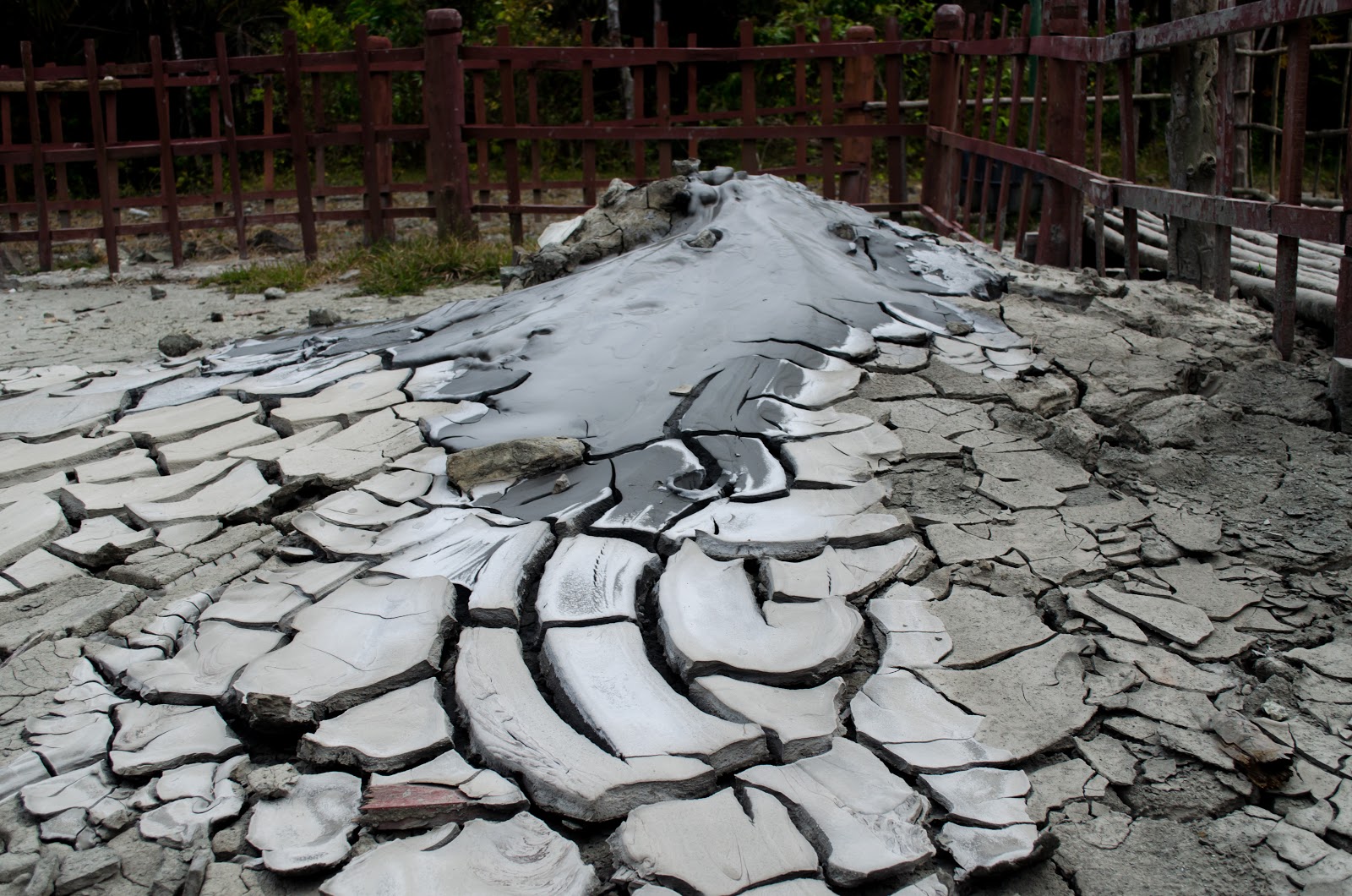
Baratang island is about 100km from Port Blair. The road to this island goes through dense forests populated by the Jarwa Tribespeople. The island boasts the only limestone cave in these parts and the only mud volcano in India.
Limestone cave, Baratang

Mud volcano, Baratang

3. Rangat/ Middle Andaman:
Spending a night at Rangat, a small town in Middle Andaman is a good idea because it lets you enjoy gorgeous sunrises on the beaches like Amkunj, Morice Dera. On your way to North Andaman, you can also enjoy a walk through dense mangroves at Dhanninallah Mangrove Creek. And the lush forest can be enjoyed much better during day-time.
Amkunj Beach, Middle Andaman


4. Mayabunder:
Mayabunder is a scenic port in Middle Andaman.
5. Diglipur/North Andaman:
Diglipur is the main town of North Andaman. You would find pristine beaches like the Kalipur Beach, known as a breeding ground for sea-turtles. Twin islands Ross & Smith, connected by a sand bridge is a sight to remember.
Kalipur Beach, Diglipur, North Andaman

6. Havelock Island:
This island is probably most popular after Port Blair. Famous for great white beaches and emerald blue waters, Havelock is a magnet for tourists all over the world. Radhanagar beach is by far the most popular. Elephant beach is known for water activities like scuba diving, snorkeling and other joy rides. One of the most beautiful beaches, which will give Radhanagar a run for its money is the Kalapathar beach.
Kalapathar Beach, Havelock Island

7. Neil Island:
A small neighbour of Havelock, this island is by no means any less attractive. Sitapur beach offers probably the best sunrise in all of Andaman. Lakshmanpur beach houses the iconic coral arch. Bharatpur beach is adjacent to the jetty and a popular destination for glass-bottom boat ride and swimming.
Sunrise from Sitapur Beach, Neil Island

8. Ross Island:
An island where you can see the remnants of the lavish life British Army officers. The island is full of destroyed structures like a church, some houses and most of them are reclaimed by nature. It is definitely a must-see place.
There are other islands to explore if you want to explore the islands even more (as you should) add the following
1. Parrot Island
2. Long Island
3. Visit  Ross Island, North bay island & Jolly boy-Redskin islands in two days
4. Hike to Mount Harriet
Deer in Ross island

Nature reclaimed structure: Ross Island

9. Little Andaman:
All of the tourism agencies will tell you "There is NOTHING to see or do in Little Andaman" and they are dead wrong.
It is a paradise island far (80 nautical miles away) from the "madding crowd". If you want to live a few days in peace, have some privacy in the lap of nature then this is the place to visit.
Only government-run ships go from Port-Blair to Little Andaman and that too not daily. So you have to plan ahead and keep a day or two as a buffer. The tickets are very cheap and the journey takes about 6 to 8 hours depending on the weather condition and speed of the ship.
This island has the only waterfall in the entire Andamans. The pristine beaches are a treat for eyes and the perfect blue water is amazingly relaxing.
This was just a brief introduction to the wonder that is the Emerald islands. Do not fall for the statements like 'there is not much to see', '5 days are enough'. Decide on your own, ask yourself what you want out of this vacation.
Leave comments on how you liked my post. For more information, stay tuned or ask me questions.

Thursday, 18 April 2019

Zwischenahner Meer: A lake which comes alive every spring

The Zwischenahner Meer is a lake situated in Ammerland , Lower Saxony, Germany (Near Bad-Zwischenahn). It is a popular place for the locals to feast their eyes on the deep blue still water of the lake and walk along the banks of the Meer.

How to Reach: 

From Bremen: RE4430 train (Get off at Bad Zwischenahn)
From Oldenburg: Bus 350 

The place is full of restaurants and cafes offering delicious food of various cuisines. You could enjoy a day in the sun, walking through the flower garden with ice-cream in your hand (and preferably the hand of a special person in the other).

There is a ferry service which runs between a few peers of different sides of the lake. The lake is not that deep, according to Wikipedia the deepest part is just 6 meters.


Monday, 15 April 2019

Key Monastery, the Spiritual El Dorado of the Himalaya

If you have read my Hampta Pass blog you will know that unlike most people we did not conclude our trek at Chhatru and ride back to Manali but instead, we ventured further into the cold desert named Spiti Valley.

Key Monastery
Here is a map to visualize the route.


Stranded at Chhatru:

On 1st July, we reached Chhatru at about noon after finishing the last day of our Hampta Pass trek. Just as we reached the camp we were made privy to a really bad news. Due to incessant rain for the last few days, the only motorable road to Manali via Rohtang Pass was cut off and the cars which were supposed to take us to Chandratal had not arrived. This setback poured cold-water on hundreds of people's plans as they were all stranded at Chhatru without any cell network. The only land-line was available after a 1 km hike to a private farm owned by some retired colonel.

Chhatru


After standing in line for nearly an hour we managed to call our travel agent and he assured that a car will come the next day as planned and pick us up. Unfortunately, we had to spend the day at Chhatru instead of seeing the fabled Chandrataal (the moon-lake).
After almost a week we were lucky enough to see a brilliant starlit sky together with a dazzling moonlit landscape. The sight was surreal and my photographs, taken with a mere kit lens; let alone my words can do justice to it.

After a good night's rest, we went out for a stroll and realised the situation was far worse than we thought. The queue of stranded cars now extended for more than a kilometer and at least a thousand people are now stranded. The situation was made much worse because of lack of communication. People were panicking and out of nowhere came this rumour that we are going to be stranded for at-least 3 days more. This rumour spread like wildfire and sent people into a frenzy, some started buying large quantities of biscuits and other dry food, some suddenly decided to cross the Hampta Pass on foot, it was utter pandemonium.

Sole Telephone booth near Chhatru
In order to try and establish contact with our travel agent again, I and my brother went to the phone-booth and found a much longer queue than the last day. After 1.5 hours I thought I heard someone calling my name in a distorted way "Protu Das !! Protu Das !!". Turning back I saw a small fellow with obvious Mongolian features and asked him who he was. He told me that he was the driver who would take us to Kaza. We came to know that the Rohtang Pass had just been opened and he himself came from Manali. Elated, we headed back to the camp and without much delay packed up our things and started our journey shortly after noon.


A Different World


Just after a few minutes, we realised what a visual treat we were in for. My team-mates had previously criticised me for planning such a trip where the journey was more time demanding than the stays. Now they realised that the landscapes of Spiti Valley are of unmatched beauty and the contrast to the lush green hills we are so used to see was very stark.

The hills were of no particular colour, every hill had its own hue, its own texture and strong wind eroded away the softer sedimentary rocks for millions of years and created spectacular gravity-defying abstract sculptures.

The path is barely motorable, it is full of small boulders and sometimes we had to roll up the windows to prevent dust from getting in. After one and a half hour, we reached Batal. It is about 31 km from Chhatru and from here the road to Chandrataal splits off from the (so-called) Highway. Batal it is only 15km from the beautiful Chandrataal. We sighed collectively as we went past the road leading to Chandrataal. That road was also closed due to heavy landslides and even if it were open we could not afford a night there. For now, it remains in our bucket-list.
Losar and eroded mountains in the background

 At about 3.30 pm we reached Losar, a small village on the way to Kaza. It is about 65 km from Chhatu and 5 hours of continuous roller coaster of a car ride caused a severe hunger attack. We entered a small roadside restaurant and ate like we survived an apocalypse.
Rejuvenated by toast, omelette, noodles and cups of coffee once again we hit the dusty road. Every turn looked more beautiful than the last and we would often irritate the driver by asking him to stop frequently. Seeing that the daylight is fading fast we refrained from these unscheduled photo ops and at about 7.30 pm we reached the Kaza bus Stand. The office of the agency (Spiti Valley Tour: 9418537689) had already been closed and hence we boarded a nearby homestay owned by a local elderly woman. The strict business-woman refused to budge from her price even when we called her 'Didi' affectionately, tough bird !
After a sumptuous dinner, we surrendered our tired bodies and dreamy minds to the fluffy (but heavy) blankets. the oxygen depleted air did not let us sleep peacefully though.

  KEY MONASTERY


After a really heavy breakfast, which raised a few eyebrows in a small sweet-shop we reserved a car which took us to the Key Monastery. The Key Village is about 15-16 km from Kaza and the majestic key monastery looks over the village. A single glance at the magnificent structure is enough to instill a sense of mystery and awe into the hearts of the beholders. At the base of the monastery, there is a small cafe cum hotel with well-decorated rooms but we marched on towards the upper reaches of the Gompa.

The office was on the same floor as the main worshiping hall. I hesitatingly approached an elderly Lama and asked him whether we are allowed to stay inside the monastery. With a polite smile, he pointed upwards and said: "talk to the guy upstairs."
As we climbed up the entire valley opened up to us and the 'guy' explained that only a dormitory is available and the toilets were outside the dorm in the corridor. At that point we could not care less, the dorm had a ROOF. The roof probably had one of the best views imaginable and we stood there, spellbound. We could see the Key Village, the green pastures and the Spiti river meandering through the valley like a great serpent. The sky was unbelievably blue and the slight cold breeze made everything PERFECT.
Just look at the pictures, my feeble attempts to describe the scenery by using just words will be blasphemous.


After freshening up, we went for a stroll to soak in the view from every viewpoint. We were happy as larks, we could not believe our luck; we were staying at the place made of fairy tales and that too for only 250/- per person including food and lodging. We had missed our lunch by half an hour because the monks follow a strict routine, which the guests also must abide by.

In the evening we were served milk tea and barley or some other brown millet flour. seeing that we were expecting something more he explained that we should pour the tea into the bowl of flour and mix them and then eat the mixture. With 2 spoonfuls of sugar, it tasted quite good. But frankly, it was not enough to satiate our hunger, so we smuggled in veg  pakora into the monastery (not sure if it was against the rules or not, Lord Buddha forgive us). Sitting on chairs and spare mattresses on the roof, chatting over hot cups of tea and pakoras, breathing in the cold mountain air, enjoying the scenic beauty as the sun began its journey behind the rocky peaks; I asked myself: "Can life get any better ?"
The depleted levels of Oxygen in the air took a toll on one of our team-mates.  After a simple dinner, we turned in for the night.
The next morning we scrapped our plan to trek 6.6 km uphill to Kibber, arguably the highest altitude village in India. We were served a heavy breakfast of a lentil soup and a type of oily bread. As we entered the sanctum sanctorum of the monastery to pray for our safe return something beautiful caught our eyes. The little monks were sitting in queues waiting for their share of the breakfast and almost everyone was beaming ear to ear. Life and happiness is probably not as complicated as we think. We make it complicated by introducing desire, competition and ego, here amidst the towering mountains, those seems quite irrelevant.


With a strange sense of contentment we boarded the sole bus to Kaza. The next day we would retrace our path through Losar, Kunjum Pass, Chhatru and reach Manali. Only this time we would go through Rohtang pass by bus unlike how we came, crossing the Hampta Pass on foot.


Even after all these months as I am writing this down, just the memories of that place is enough to give me goosebumps allover.


Monday, 2 April 2018

Hampta Pass : Gateway from Kullu to Spiti

The most baffling thing about the Hampta Pass trek, which sets it apart from the plethora of treks in the Himalayas is neither its remote location nor the challenges it offers but the absolutely contrasting vistas presented by the lush green Kullu valley and the rugged and dry Spiti valley. The high mountain pass acts as a gateway to an entirely different world, very few treks offer this dramatic transition. I shall now delve into the details of this trek objectively, before telling my own experience.


Location: 

The popular approach is from Hampta dam which is located at a distance of about 12km from Manali in Himachal Pradesh. From there the trek starts and after crossing the pass ends at Chhatru /Chatru, a small village on the Gramfu-Batal-Kaza road. The trek can also be done the other way round.

For your reference here is a map for the entire trek route assuming you will return via the Rohtang Pass to Manali.

Season: 

Try avoiding the monsoon at all costs. October - early November is definitely the best season. The roadway remains closed due to heavy snow accumulation till mid-August. 
A note of caution: The travel agencies will tell you anything to keep their business running all year long, but do not make the mistake of taking any trek lightly irrespective of the tags like 'easy', 'moderate'. Depending upon factors like weather, River level which are beyond human control,  a so-called easy hike in the Himalayas may seem to be an insurmountable obstacle.


Monday, 13 March 2017

Pindari Diaries

The entire Northern part of the Indian Subcontinent forms a giant biosphere. This eco-system, one of the most diverse in the whole world, owes the abundance of life to several great rivers flowing thorough this region. And all of these rivers starts from the high glaciers of the Himalayas, the largest and tallest of all mountains. It comes as no surprise that billions of people of these regions humble themselves at the feet of these mountains and rivers. We literally owe our lives to the Great mountains and mighty rivers that flow from them. For centuries these pristine glaciers have attracted adventurers and pilgrims alike.
I along with my friends followed the Pindar river to the fabled Pindari glacier (3660 mtrs) and the journey has been a fabulous experience for us.

Warning Signs; An Appeal:

The glaciers melt throughout the year and form the rivers and every winter it rebuilds itself from rain and snow. But due to global warming, the average temperature is rising every year and the glaciers are melting away at a much faster rate than it can build itself. This glacial recession is happening right now, and it is happening more rapidly than the glaciologists have anticipated. When I visited Pindari glacier and compared the current state with the photographs my mother took, about 30 years ago, I was shocked to see how much of the glacier had eroded away.

I urge the readers to do their part to make sure these glaciers survive, otherwise the entire ecosystem will be devastated within this century.
1. Do not litter the trek routes, carry back every bit of plastic you bring with you.
2. Do not cut tree branches unnecessarily . Do not pick flowers or plants.

" Take nothing but photographs, leave nothing but footprints"  

Pindari Glacier

Season:  April -May; September - October

Tuesday, 21 February 2017

Chilling Out in Style at Jilling

We all want to escape from our daily pre-programmed life every once in a while. Genetically human beings are wanderers and instinctively we crave something new, something different. For most people a small vacation is enough to rejuvenate their soul. If you love mountains, wilderness, isolation, tranquility then I suggest you spend a few days at Jilling, where you can have it all.


The Jilling Estate is essentially a privately owned forest in Kumaon region of the Himalayas. The entire 120 acres of land is devoid of any human settlement apart from a few well decorated cottages, which are built in secluded locations. For many of us it is not possible to camp in the wilderness and experience nature's dangerous beauty firsthand. Jilling home-stays are designed to give you exactly the feeling of being one with nature without compromising luxury and comfort.

When I read about Jilling and the Lall family in a travel magazine, I was intrigued and without wasting any time contacted Nandini Lall. She is the daughter of Steve Lall,  the landlord of Jilling Estate. As on 2017 the rates are 3000/- per day per person including dining and guided tours of the estate.

Sunday, 19 February 2017

Phoktey Dara ; A Peep in the Lord's Bedroom

Kanchenjungha comes from two Sanskrit words, Kanchan which is another name for the Hindu God of creation and destruction, Lord Shiva and Jangha meaning thigh. The entire Kanchenjungha or Kanchendzongha range looks like Lord shiva is sleeping and the main peak forming his raised thigh. No wonder when Buddhism spread and took hold in this part of the land Kanchendzongha became the sleeping Buddha. The more popular theory is that Kanchendzonga comes from 5 Tibetan words 'gangs' (snow), ' chen' (great), 'zgod' (treasure) and 'nga' (five).   In any case towering 8586 metres above sea level, the 3rd highest peak of the world is one of the most beautiful snow covered massif in the Himalayas. The sheer size of the mountain , precipitous peaks dwarfing everything​ around it, brings a sense of awe to the beholder.


Kanchendzongha/Kanchenjungha


Phoktey Dara is a hilltop situated near the intersection of three borders, Sikkim, West Bengal and Nepal, and it offers spectacular views of not only the Kanchenjungha range but also several Chinese peaks and Giants of Nepal, Mt. Everest, Lhotse, Nuputse and Dhaulagiri. But to behold this heavenly site a good bit of hard work and sweat is required.


How to get There :


Phoktey Dara is a total 3 day trek from the village of Uttarey in West Sikkim. One can reach Uttarey in a single day from New Jalpaiguri Railway station or Bagdogra Airport.
You can  opt to reserve your own transport if you have a 6-10 person group or budget is not a constraint for you. Otherwise shared jeeps are available but you have to break several times.

Phoktey Dara


Wednesday, 15 February 2017

Satkosia ; A Hidden Gem on The Bank of Mahanadi

The diversity of flora and fauna that we Indians are blessed with is facing devastation. Pollution, poaching, deforestation, urbanisation, large-scale hydro-electric projects all of these factors and more are catalysing this cataclysmic phenomenon. The most alarming part is the lack of awareness of our people and our utter ignorance. Tourism can help raise awareness if done in a eco-friendly manner. When in the wilderness we must tune ourselves in such a way that we do not leave any lasting impact on that place. A wilderness explorer must be a silent observer.
Satkosia Tiger Reserve boasts a diverse gorge eco-system with deciduous plants. It is situated at the bank of river Mahanadi, the largest river in the state of Orissa. A great place for wildlife enthusiasts to spend a few days in.

Tikarpara Nature Camp


BOOKING:

Booking and entry permit is done officially through the website of Orissa eco-tourism.
https://www.ecotourodisha.com/index.php
 Please check the current rates from the site. At the time of our booking it was around 2500-4000 Rs. for 2 persons (Including food and lodging) depending on the location. But the online transaction takes a whopping 10% of the total amount as transaction fees. Another thing to note is that the payment portal DOES NOT accept RUPAY cards ( even though that is not mentioned in the website).
Alternatively you can try your luck by spot booking , that would spare you the transaction charges, but I would not advise that. You can stay at one place for maximum of 2 days at a stretch.

Here are a few contact numbers:
DFO Office Satkosia: +918763102681
Shamim Chauhan (Site Manager Satkosia) : +8658023333


Sunday, 6 November 2016

Visakhapatnam and Araku Valley; A refreshing short trip

Visakhapatnam or Vizag is a bustling city on the coast of the Bay of Bengal. Despite being the most populous city in Andhra Pradesh it is surprisingly clean and a popular tourist spot. This particular tour is almost mandatory for Bengalis and they like to throw in theBora caves and the beautiful Araku valley in the mix. The entire tour can be done in only 5 days. So I am just gliding over the facts of this tour, the history and mythological essence can be studied at your own leisure.


 ITINERARY: 
Day 1: Reach Visakhapatnam. (Preferably in the early morning). Visit to some of the places of interest.
Day 2: Catch the train to Araku Valley. Visit Bora caves. Night stay at Araku.
Day 3: Journey back to Visakhapatnam.
Day 4: Realax. Catch a train back.

Obviously you can extend the program by 2-3 days by staying an extra day at Araku and Visakhapatnam.

Thursday, 26 March 2015

Trekking , My views

I am not a "Serious" trekker (No, I take it very seriously and love it, you probably get what I mean) and nor do I think it should be a serious affair. I have only done a very few treks and so my opinion in this matter does not carry a lot of 'weight' so to speak.

This is mostly to give interested folks an idea about what trekking is 


MYTH 1 :

Trekking = Mountaineering

I find that many of my  friends are interested in "Trekking", the first impression that this word creates to them  is "Scaling mountain peaks with ice-axes and ropes", no trekking is NOT "Mountaineering". Trekking is experiencing a landscape (not necessarily hilly regions ) on foot without any strict goal or deadline to meet (As opposed to Expeditions).
Its a great way to experience a bit of danger , a bit of tranquility. Trekking brings out deeper bonds between friends, hidden strength and determination in side oneself and most importantly its hugely fun. The breathtaking scenery is the rewards and precipitous mountain peaks dwarf one's life's mundane problems and help put things into perspective.

MYTH 2:

Harder = Better

A trek is considered hard because of many reasons:
  1. Steep gradient : Will drain you both physically and mentally
  2. Technically tough : Requires maneuvering some tricky terrain
  3. Remoteness : No civilization nearby
  4. Height : Altitude sickness is a possibility.
Now at higher altitudes and remote locations you are bound to get closer views of mountain vistas but that does not mean easier treks are less rewarding as far as scenery is concerned. If you are too drained after a tough trek you won't be able to enjoy even the most marvelous of  views.

Trekking is not only about pushing yourself to the limit but mostly about enjoying nature with you in it.

MYTH 3 : 


Expedition/Mountaineering >> Trekking (Trekking is for sissies)

Comparing mountaineering with trekking is like comparing a formula one race with a joyride in a convertible.
Yeah there is absolutely no doubt that mountaineering is much more challenging, more technically demanding and far more dangerous and its certainly not for everyone. But that is exactly why trekking is more fun, its less expensive, it has more room to change your plan according to your whim, you are not bound. Basically the happy-go-lucky way of a trek is its main charm.

Some suggested first Treks in the Himalayas:


For beginners I would suggest the following treks according to my own preference:
  1. Sandakphu - Phalut
  2. Har-ki-Dun
  3. Valley of Flowers
  4. Hemkund Sahib
  5. Gomukh
  6. Dodital
  7. Tunganath-Chandrashila
  8. Madmaheswar  
Of-course there are a lot more but these are the most common.

Note:

  1. Take a even though you feel like you know everything about a route. They can help you when you really need it.
  2. Take basic medications.
  3. In case of severe altitude sickness while ascending , turn back immediately and go down to a lower altitude.
  4. Always show respect to local people . They are one of the nicest people on earth.
  5. Help the local people in any way you can. Inspiring others to visit can boost local tourism and help the local people a lot.
  6. Do not litter .


Thursday, 5 February 2015

Santragachi ; A lake full of life (weekend tour 2)


Santragachi is a nice weekend destination close to Kolkata , specially in winter. If you are planning to spend the weekend in bustling shopping malls and admiring splendid landmarks of Kolkata, I recommend that you throw Santragachi into the mix. You don't have to be an avid birdwatcher to relish the beauty of this place.


Lets get down into the details.........


Disclaimer: I neither have the expertise nor the equipment needed to take good photographs of birds from long distances. So don't let my mediocre (at best) photographs kill your interest.


The Santragachi Jheel (Lake) is 13,75,000 sq ft in size and attracts thousands of migratory birds each winter and bird watcher from all over West Bengal flock together as well.


Common Moorhen (Adult)


HOW TO REACH?

1. Reach Howrah Railway Station (Its one of the busiest railway stations in India with most train handling capability..not that hard to find )
2. Board local trains in South-Eastern Railway section.
3. Get down at Santragachi station.

Bronze-winged Jacana


WHY SANTRAGACHI?


1. Its pretty close to the city of Kolkata (Calcutta).
2. Many species of birds are found here, in a relatively small area.
3. Easy to reach.
5. Many nature clubs organize awareness camps for general public where one can meet expert ornithologists.


Lesser_whistling_Duck


WHEN TO VISIT?

Preferably winter when migratory birds flock together. But birding enthusiasts visit throughout the year as different birds come here at different seasons.
I would suggest late January- February.

Northern Pintail


BIRDS FOUND:

  1.  Lesser Whistling
  2. Northern Pintail
  3.  bronze-winged jacana
  4. Cormorants
  5. Egrets
  6. Purple Heron 
  7. Moorhen
  8. Common Coot
Several other species are found here. 

Cormorant


AN APPEAL :


Over the years the number of birds coming to these lakes have fallen drastically all over India and Santragachi is no different. Recently many houses are being built beside the lake and some of the locals do not feel any duty towards preserving the lake eco-system.
So, please do not throw any garbage in or near the lake and try to persuade others not to do the same. A little step taken by you may make a big difference and help preserving the lake.


White-throated Kingfisher

 
Please feel free to ask anything or correct me if I am wrong anywhere.
 

Portugal in a Week: From North to South [Part 2: Day 1]; PORTO

 Porto is situated at the banks of the meandering Douro river in the north-west of Portugal. It is one of the most picturesque cities in all...